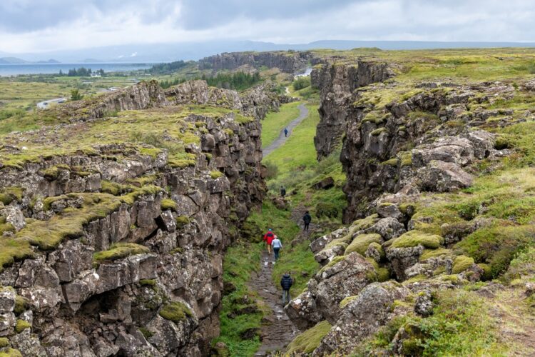
Situated in southwestern Iceland, just 49 km northeast of the capital Reykjavík, Þingvellir (Thingvellir) National Park is a place of immense historical, cultural, and geological significance. The park covers 24,000 hectares, with 9,270 hectares constituting a UNESCO World Heritage Site. The powerful geological forces that have shaped this remote site are still at work today.
Central to Þingvellir’s historical importance is its role as the original site of the Alþing (Althing), Iceland’s parliament, which was established around 930 AD. The Alþing was an open-air assembly that convened annually for two weeks, serving as both a legislative body and a high court of law. Chieftains from across Iceland gathered at Þingvellir to discuss matters of national importance, settle disputes, and proclaim new laws. These laws, seen as a covenant between free people, were memorized and recited by an elected Lawspeaker. The stone cliffs surrounding the area when the people gathered form a natural amphitheater.
The Alþing at Þingvellir continued to function as Iceland’s central governing body for nearly nine centuries until 1798. It was a remarkably sophisticated and equitable system of governance for its time, giving voice to a large segment of the male population. The Alþing laid the foundation for Iceland’s strong democratic traditions and identity as a sovereign nation.
Today, visitors to Þingvellir National Park can see the physical remains of this long history. Fragments of around 50 booths built from turf and stone are scattered across the landscape, serving as temporary shelters for those who attended the Alþing. Further remains from the 10th century are thought to lie buried underground, waiting to be unearthed by archaeologists.
The park also contains other historical structures and archaeological sites. The Þingvellir Church, a beautiful wooden structure built in the 19th century, stands near the ruins of an older stone church dating back to the 11th century. Adjacent to the church is an old farm site with remnants of agricultural activity from the 18th and 19th centuries. Collectively, these sites offer a fascinating glimpse into how the area around Þingvellir has been used and inhabited over the centuries.
Þingvellir’s historical significance is matched by its geology. The park lies in a rift valley that marks the boundary between the North American and Eurasian tectonic plates. The movement of these plates has created dramatic fissures and cliffs in the landscape, vividly illustrating the geological processes of continental drift. Þingvellir’s landscape continues to evolve. Earthquakes are frequent occurrences, and the valley floor has subsided by 3-4 meters since the Alþing was first established.
One of the most remarkable features in the park is the Almannagjá gorge, a deep, narrow canyon formed by the divergence of tectonic plates. Visitors can walk along well-maintained pathways through the gorge, marveling at the towering rock walls on either side. The Öxarárfoss waterfall, fed by the Öxará river, plunges into the gorge, adding to the site’s scenic splendor.
At the southern end of the park lies Þingvallavatn, the largest natural lake in Iceland. The lake, which covers an area of 84 square kilometers, was formed by a combination of glacial activity and subsidence of the surrounding landscape due to tectonic rifting. Þingvallavatn is remarkably clear and pristine, and is home to a unique population of Arctic char, a cold-water fish that has evolved in isolation for thousands of years.
Beyond its historical and geological importance, Þingvellir holds immense symbolic value for the people of Iceland. The site is closely associated with the country’s struggle for independence and the formation of its national identity.
the 19th century, as Iceland sought to break free from Danish rule, Þingvellir became a focal point for the independence movement. The historical significance of the Alþing was celebrated in literature, poetry, and public discourse, with Icelanders looking to their Viking Age ancestors as models of self-governance and freedom.
Today, Þingvellir is widely regarded as a shrine to Icelandic nationalism and a symbol of the country’s resilience and independent spirit. The park attracts hundreds of thousands of visitors each year, including many Icelanders who come to connect with their history and heritage.
Recognizing the exceptional value of Þingvellir, the Icelandic government established the site as a National Park in 1930. The park has been managed by the Þingvellir Commission ever since, with a focus on preserving its natural and cultural heritage while providing sustainable access for visitors.
In 2004, Þingvellir National Park was inscribed on the UNESCO World Heritage List in recognition of its outstanding universal value. The World Heritage property includes the park’s core area of 9,270 hectares, encompassing the Alþing site and its surrounding landscape. A larger protected area of 14,730 hectares serves as a buffer zone, providing an additional layer of protection.
Like many popular tourist destinations, Þingvellir faces challenges in balancing preservation with accessibility. The park has seen a steady increase in visitor numbers in recent years, putting pressure on its natural resources and infrastructure. The Þingvellir Commission has responded by implementing a comprehensive management plan to ensure sustainable tourism practices and minimize negative impacts on the environment.

